Early in my career, I was drilling on the Woodstock Drumlin Field for my M.Sc. research on evaluating agricultural best management practices for source water protection. I frequently took cores, only a few meters apart, and stratigraphy was not able to help me to delineate hydrogeological units for my conceptual site model. Since then, I strive to advance models of spatial dependence, make them more realistic, and apply them in practice. I am very happy that my work is the basis for the program that is used by the state agency of the environment in Baden-Württemberg (LUBW) to monitor the state of the quality of the state's groundwater for about 200 solutes across the entire state. This is one of the view world leading data-driven operational models.
I apply geostatistical concepts for a variety of environmental parameters such as precipitation, hydraulic conductivity, solute concentrations in river sediments, soil moisture, heat in the subsurface, and many more. These parameters affect the hydrological cycle in hydrosystems at various scales such as contaminated sites, irrigated agricultural watersheds in arid environments, and groundwater quality on the regional scale.
Generally, I believe that water is an essential natural resource. For meaningful management of this vital resource quantification of its states in all compartments is necessary. This is an inherently collaborative endeavour.
Spatial Dependence
The arrangement of variables in space influences various secondary variables. The classic example from stochastic hydrogeology is that the structure of hydraulic conductivity influences groundwater velocity and subsequently solute transport behaviour (macrodispersion).
My core research interests include multivariate non-linear spatial dependence structures, associated parameter estimation methods, spatial interpolation and simulation techniques, inversion, as well as quantifying the effects of non-linear spatial dependence structures on dependent properties, such as solute transport behaviour.
Particularly, we are working at the moment on the estimation of the spatial dependence of a given variable, given that this variable was measured using different measurement techniques, at not-identical locations.
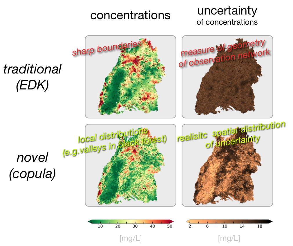
Together with colleagues at the University of Stuttgart, I am actively developing an operational code for the interpolation of groundwater quality parameters on regional scale. This project is in close collaboration with the state agency of the environment in Baden-Württemberg. Overall goal is to include as much information as possible to enhance the model of spatial dependence (hard and soft secondary information / exhaustive and non-exhaustive). As spatially distributed data is always sparse, particularly in the subsurface, it is mandatory to look at other kinds of data that are more frequently available, easier to measure, and / or cheaper. For example, I have successfully used locally averaged land-use information (categorical information!) to enhance the spatial dependence model of anthropogenic groundwater quality parameters, which leads to improved and more realistic maps and to a much improved uncertainty, particularly an improved spatial structure of uncertainty. While a key component of the code is in operational use since 12/2017, we are expanding this work to actively estimate probabilities of exceedance of critical thresholds.
On a scale beyond one hydrogeological unit, knowledge of geology and geological structures can help to improve the understanding of solute transport behaviour. Geologically realistic features can be modelled using the object-based code HyVR, that a previous student of mine has developed.
Contaminants of Emerging Concern
There are many contaminants that have been around for only a short amount of time. Our understanding of the processes of the reactions and associated rates is limited. One option that I have been taking is to use stochastic tools into which I integrate as much information as possible to simulate the spatial distribution of a contaminant (and not a pde-based model). The interpolation of the groundwater quality parameters in Baden-Württemberg of most of the 200 solutes serves as a reasonable example.
At most locations for most of the time, emerging contaminants occur at very small concentrations, often below detection limit. I have developed and applied methods that incorporate such "censored measurements" (measurements within an interval) and lead to better decisions. The above mentioned groundwater quality monitor for Baden-Württemberg incorporates censored measurements. Also when such measurements below detection limit were included in the estimation of expected mass at a site contaminated with chlorinated solvents, I was able to estimate the masses of the individual compounds better such that they fit in the conceptual model of the site and the decay chain of chlorinated solvents. I was also able to better estimate the expected mass in the relevant hydrogeological unit, which aides remediation design, for example for in-situ chemical oxidation (ISCO) or injections of nano zero-valent iron (nZVI).
Per- and Polyfluoroalkyl Substances (PFAS) are a group of emerging contaminants of particular interest to the state of Baden-Württemberg. At VEGAS we are developing a test methodology for immobilization of PFAS that I accompany with exploratory modelling with the goal to identify relevant processes in PFAS' solute transport behaviour and to estimate the associate rates.
Heat Transport in the Subsurface
VEGAS is key knowledge is in the development of in-situ remediation technologies. One key remediation technique is to heat the subsurface above the azeotropic temperature of a given contaminant cocktail. I am aiding to improve design tools for thermal remediation systems. I am also transferring this knowledge into the domain of seasonal heat storage in the shallow subsurface environment.
Water Resources Management
The topic of my M.Sc. thesis was an evaluation of agricultural best management practices for source water protection for a public drinking water supply in Southern Ontario. The result of this work is that the City who is responsible for the supply has not seen the need to spend money for the construction and maintenance of a treatment plant. Instead, with the money saved by continuing best management practices in the vicinity of the well field, they built a public library.
Based on my master thesis work I have experience in field based hydrogeology and numerical modelling: I collected field data (e.g. drilling, well installation, coring, aqueous geochemistry, electrical resistivity, EM, tile drain sampling), analyzed and interpreted that data, and used it to build a numerical model in FeFlow.
The interplay of data and models, ideally with reasonable and innovative representations of heterogeneity in space and time is still of interest to me, for example related to water resources management in arid environments or in improved modelling strategies for evapotranspiration. I have been closely advising two PhD students who evaluated the effect of both recently started irrigation and climate change on nitrate in an arid agricultural catchment in Spain.
Together with a plant ecologist, I am advising a PhD student who is evaluating the impact of dynamic vegetation (models) on hydrogeology. The vegetation model is an agent based model describing various plant traits. The plants compete for water. We couple the need of the plants with the availability through a hydrogeological model.
Numerical and conceptual models are a key components to understand processes and evaluate management options. I have experience with state of the art numerical ground water and surface water models (HydroGeoSphere, dumux, FeFlow, mHM, HEC-RAS).